
Drone Mapping & Site Progress Monitoring
Orthomosaic drone mapping for construction sites, property development, infrastructure inspection, and environmental monitoring.
High-resolution aerial maps allow clients to measure, document, and analyze large areas with centimeter-level accuracy.
An orthomosaic map is created by combining hundreds or thousands of overlapping drone images into a single accurate aerial map. Unlike standard drone photos, orthomosaic maps provide a true top-down view that can be measured and analyzed.
These maps are commonly used for construction planning, site documentation, property development, infrastructure inspections, and environmental monitoring.
What Makes Orthomosaic Maps Valuable for Clients
Compared to normal drone photos, orthomosaics allow:
✔ Precise measurements in minutes
✔ Accurate mapping of large areas
✔ Historical comparison over time
✔ Zoom into small details across entire sites
✔ True top-down perspective without distortion
✔ Extremely high resolution imagery
Using the DJI Mavic 3 Enterprise with RTK positioning, Sky High produces highly accurate aerial maps suitable for measurement and analysis.
RTK positioning improves positional accuracy and allows clients to confidently measure distances, areas, and site layouts directly from the map.
Track Site Progress Over Time
One of the most valuable features of drone mapping is the ability to capture a site repeatedly and build a visual timeline.
With archived imagery, teams can:
• Review previous site conditions
• Verify when work was completed
• Identify damage or unexpected changes
• Investigate missing materials or equipment
• Compare development progress over time
This historical record provides a reliable way to understand exactly what happened on a project site and when.
See Details Traditional Maps Miss
Public map imagery is often outdated, low resolution, or captured before important site changes occurred. Drone mapping provides current, high-resolution imagery captured on demand, giving stakeholders an accurate view of the site as it exists today.
• Current site conditions
• Sharper detail
• Accurate top-down perspective
• Captured on your schedule
Interactive Mapping Demo – Peter Iredale Shipwreck
Explore this interactive orthomosaic of the Peter Iredale Shipwreck at Fort Stevens State Park. This example demonstrates how drone mapping can be used to measure and analyze real-world locations.
Use the map tools to experiment with:
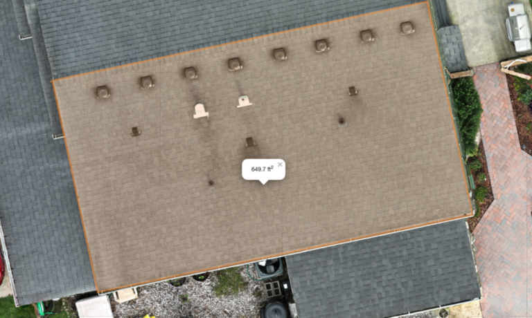
Square Footage – measure the area of structures or sections of the beach
Polygon Area – outline irregular shapes such as parking areas or shoreline features
Line Distance – measure distances between points on the map
Radius – calculate circular areas such as staging zones or safety buffers
High-resolution aerial maps like this allow teams to quickly measure, document, and analyze large areas without needing to physically survey the entire site.
Practical Uses for Drone Mapping
High-resolution orthomosaic maps support planning, measurement, and documentation across many industries.
Common applications include:
Construction & Development
- Construction progress monitoring
- Site planning and development documentation
- Material staging and logistics overview
Land & Property Analysis
Acreage measurements
Property documentation
Roof measurements and site layout analysis
Water & Drainage Planning
Irrigation layout and water distribution
Retention pond and drainage measurement
Agriculture & Land Management
Crop monitoring and field documentation
Landscaping and grading analysis
Golf course layout and turf management
Project Tracking
Historical comparisons over time
Progress documentation for projects and infrastructure
Mapping Service Pricing
Pricing varies based on mission size, flight time, number of images captured, and processing workload.
Every mapping mission includes the same core deliverables.
Standard Mapping Deliverables
Every mapping mission includes:
- Orthomosaic aerial map
- Measurement-ready imagery
- Interactive online map viewer
- Downloadable map files for reports and presentations
- FAA airspace coordination if required
- Image processing and map generation
Typical turnaround: 24–72 hours depending on project size
Important Note on Resolution
Map resolution depends on flight altitude and image density.
Lower altitude flights capture more detail but require more images and longer processing times.
Sky High selects the appropriate flight profile to balance:
• Map resolution
• Project size
• Airspace restrictions
• Processing workload
Typical resolution ranges between 1.5 cm and 3 cm per pixel depending on the mission.
Mapping Mission Size
Pricing scales based on the size of the area being mapped and the number of images required to produce a high-resolution orthomosaic.
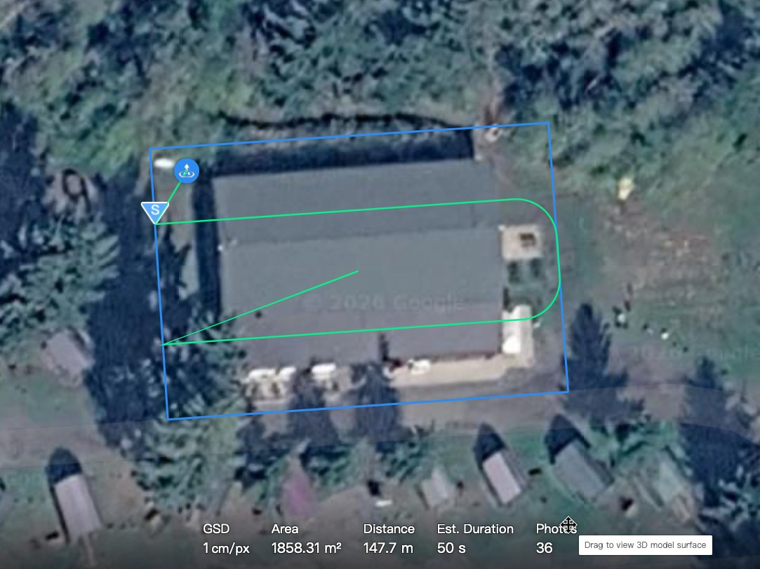
Small Project Site
$300 – $450
Up to 10 acres
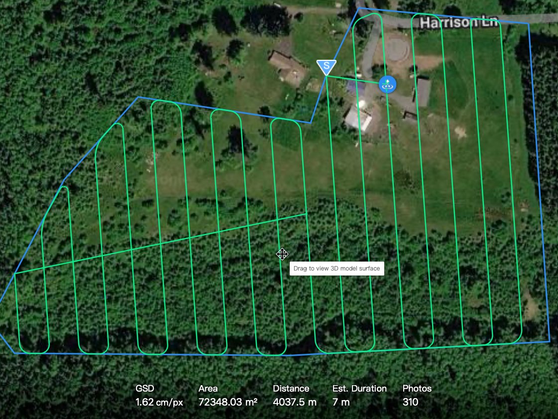
Medium Development Site
$450 – $750
10–40 acres
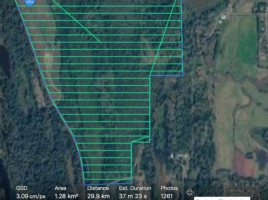
Large Project Area
$750 – $1,500+
40+ acres
Large sites may require multiple flight missions and stitched maps.
Construction Progress Monitoring
Recurring monitoring flights document project development over time.
Monthly Monitoring
$400 per visit
Bi-Weekly Monitoring
$350 per visit
Includes:
• Scheduled drone mapping flights
• Updated orthomosaic map
• Archived project timeline imagery
Optional Add-Ons
Additional analysis and reporting services are available depending on project needs.
Measurement Reports
Area calculations, distances, and site measurements prepared for reports.
Object Counts
Automated counts of materials, equipment, or other site features.
Custom Map Overlays
Project boundaries, labels, or infrastructure layers added to the orthomosaic.
Elevation Models
Digital elevation models and terrain visualization.
Annotated Project Reports
Custom PDF reports prepared using Google Earth Pro or GIS tools.
Cinematic Site Video
2–3 minute aerial video overview of the property or construction site.
Service & Data Disclaimers
Mapping Service Disclaimer
Drone mapping services provided by Sky High are intended for visual documentation, planning support, and general measurement purposes. While high-resolution aerial imagery and RTK positioning can provide highly accurate measurements, these services are not a substitute for a licensed land survey.
Sky High does not provide licensed land surveying services, boundary determinations, or legal property measurements. Measurements, distances, or areas derived from aerial imagery should be considered approximate and for informational use only unless verified by a licensed professional surveyor or engineer.
Clients are responsible for verifying measurements before relying on them for engineering, construction, permitting, or legal purposes.
Data accuracy may vary depending on site conditions, terrain, vegetation, and available GPS correction signals.
Flight Operations & FAA Compliance
All drone operations are conducted in accordance with Federal Aviation Administration (FAA) regulations, including FAA Part 107 where applicable. Flights are subject to airspace restrictions, weather conditions, visibility requirements, and operational safety considerations.
Certain locations may require airspace authorization, waivers, or property access permissions prior to flight operations. Scheduling and service availability may be affected by regulatory requirements or environmental conditions.
Image Accuracy & Representation
Aerial imagery and mapping data represent conditions at the time of capture only. Site conditions may change after imagery is collected due to construction activity, environmental factors, or other site modifications.
While Sky High makes reasonable efforts to produce accurate and high-quality imagery, no guarantee is made that imagery or data will reflect all conditions present at a site.
Property & Access Responsibility
Clients are responsible for obtaining any necessary permissions, property access rights, or coordination required to perform drone services over private property or controlled areas.
Sky High assumes that the client has authorization to request aerial services for the location being documented.
Privacy & Responsible Operation
Drone services are performed with respect for privacy and applicable laws. Sky High does not intentionally capture imagery of individuals or private activities unrelated to the project scope.
Operations are conducted in a professional manner consistent with responsible aerial imaging practices.
Environmental & Operational Conditions
Drone operations may be affected by environmental conditions including wind, precipitation, lighting, temperature, and obstacles within the flight area. In some cases these conditions may impact flight scheduling, imagery quality, or operational safety.
Sky High reserves the right to reschedule flights if conditions are determined to be unsafe or unsuitable for aerial operations.
Data Use & Liability
Aerial imagery, mapping data, and visual documentation provided by Sky High are intended for informational, planning, and documentation purposes. Clients are responsible for determining the suitability of the data for their specific use case.
Sky High shall not be responsible for decisions made based on aerial imagery or measurements without appropriate professional verification where required.
Data Storage & Retention
Sky High will retain client project imagery and mapping data at no additional cost for a minimum of 90 days after delivery. During this time clients may request additional copies of deliverables or file access if needed.
After the retention period, Sky High may archive or remove project files to manage storage capacity. Long-term data storage or archival access may be available upon request. Data will be archived for one year.
Clients are encouraged to download and securely store their project deliverables after delivery.